


Framed Nautical Map 13218 - Marthas Vineyard to Block Island
Marthas Vineyard to Block Island 13218
This Framed Nautical Map covers the waters and coast line of Marthas Vineyard to Block Island. The Framed Nautical Chart is the official NOAA Nautical Chart detailing the beautiful waters from Marthas Vineyard to Block Island; including Buzzards Bay, Vineyard Sound, Smith Neck,Newport Neck, Point Judith Neck, Naushon Island, and many other towns an harbors.
Product Details:
NOAA Nautical Chart 13218
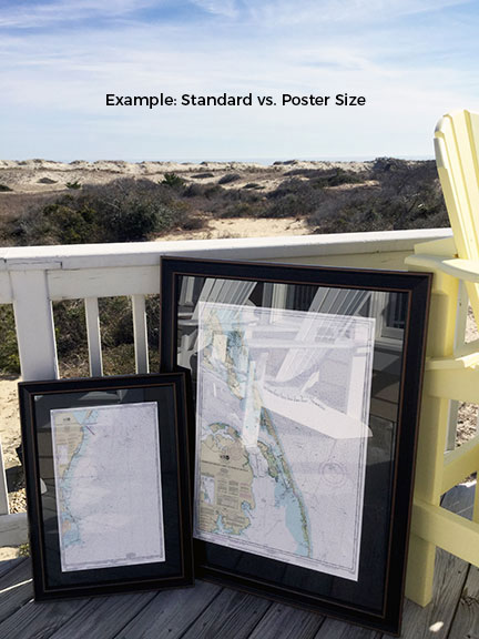
Standard frame is approx. 20 1/4" H x 24" W
Poster frame is approx. 30 1/2” H x 36" W
Solid Hardwood Frame
Glass Front
Black Matte
Paper Duster Backing with Wire Hanging
Hand Made in USA
Free Ground Shipping*
Each Framed Nautical Chart is custom hand made in the USA. Orders are typically shipped within 2 business days.
Marthas Vineyard to Block Island 13218
This Framed Nautical Map covers the waters and coast line of Marthas Vineyard to Block Island. The Framed Nautical Chart is the official NOAA Nautical Chart detailing the beautiful waters from Marthas Vineyard to Block Island; including Buzzards Bay, Vineyard Sound, Smith Neck,Newport Neck, Point Judith Neck, Naushon Island, and many other towns an harbors.
Product Details:
NOAA Nautical Chart 13218
Standard frame is approx. 20 1/4" H x 24" W
Poster frame is approx. 30 1/2” H x 36" W
Solid Hardwood Frame
Glass Front
Black Matte
Paper Duster Backing with Wire Hanging
Hand Made in USA
Free Ground Shipping*
Each Framed Nautical Chart is custom hand made in the USA. Orders are typically shipped within 2 business days.
*Alaska & Hawaii Shipping Surcharge: Due to shipping surcharges by our carriers, orders to Alaska or Hawaii will have a pass-thru shipping surcharge on all orders. Post order, we will determine the shipping surcharge and email the surcharge invoice to you. Upon completed payment of surcharge, your order will be shipped.